


Randonnée du 05/05/2024 à 09:33

Nathy8913
User
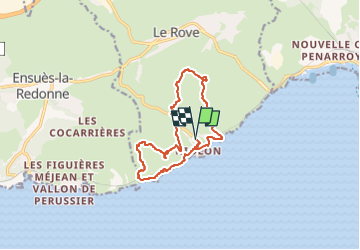

Length
13.2 km

Max alt
226 m

Uphill gradient
537 m
Km-Effort
20 km

Min alt
7 m

Downhill gradient
541 m
Boucle
Yes
Creation date :
2024-05-06 17:45:29.969
Updated on :
2024-05-06 17:55:23.172
4h37
Difficulty : Difficult

FREE GPS app for hiking
 SityTrail
IGN / Geographical institutes
SityTrail Plus
The world is yours!
About
Trail Walking of 13.2 km to be discovered at Provence-Alpes-Côte d'Azur, Bouches-du-Rhône, Le Rove. This trail is proposed by Nathy8913.
Positioning
Country:
France
Region :
Provence-Alpes-Côte d'Azur
Department/Province :
Bouches-du-Rhône
Municipality :
Le Rove
Location:
Unknown
Start:(Dec)
Start:(UTM)
682881 ; 4801284 (31T) N.
Comments